Ground Penetration Radar (GPR)
Need and Scope:
GPR is non-destructive subsurface exploration technique, which Works on the principle of Electro-magnetic waves.
Concept:
The GPR equipment is used for the measurement of subsurface conditions, which usually consists of a transmitter and receiver antenna, a radar control unit, and suitable data storage and display devices. The radar control unit synchronizes signals to the transmitting and receiving electronics in the antennas. The synchronizing signals control the transmitter and sampling receiver electronics located in the antenna(s) in order to generate a sampled waveform of the reflected radar pulses. These waveforms can be filtered & amplified and are transmitted along with timing signals to the display and recording devices. GPR is based on technique that uses high-frequency electromagnetic (EM) waves (from 10 to 3000 MHz) to acquire subsurface information. GPR detects changes in EM properties (dielectric permittivity, conductivity, and magnetic permeability), that in a geologic setting, are a function of soil and rock material, water content, and bulk density. Data are normally acquired using antennas placed on the ground surface or in boreholes. The GPR method is used to map geologic conditions that include depth to bedrock, depth to the water table, depth and thickness of soil strata on land and under fresh water bodies and the location of subsurface cavities and fractures in bedrock. Other applications include the location of objects such as pipes, drums, tanks, cables, and boulders, mapping landfill and trench boundaries etc.
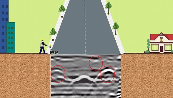
GPR does mapping of unrecorded underground assets including pipelines without disturbing the on-surface conditions. Trenching is one of the practices adopted to gather information about as-built underlying utilities. It just does not cause disturbance and inconvenience to the normal public but also lead roads to unworkable state. GPR technology can be used as a precautionary measure to map the underground assets before going for HDD (Horizontal directional drilling), utility shifting or before drilling for piles or boreholes.
Ground Penetration Radar (GPR)
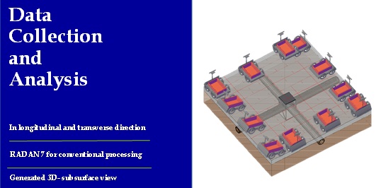
Experimental Setup:
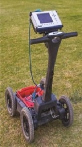
Following equipment is recommended for the purpose of utility mapping with fair resolution upto the depth of maximum 7-8 m depending upon the site conditions.
- SIR-4000 GSSI GPR system
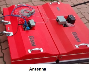
- 400MHz Antenna to cover a depth of around 1-3 m with fair resolution.
- 200MHz Antenna to cover a depth of around 2-8 m with fair resolution.
- 100 MHz antenna to locate bigger utilities at greater depth of 10-12 m.
- RADAN 7, Analysis & Processing Software with 3D visualization module.
Methodology:
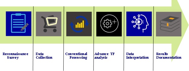
Reconnaissance survey: It involves the overall survey of the area to gather as much information as possible about the site to be surveyed, the expected depth of the possible targets and to decide the layout of the area to be surveyed and parameters of the GPR survey like the frequency of the antenna, transect spacing etc.
- Data acquisition at the site: collection of subsurface profiles and the CMP data for the EM wave velocity estimation.
- Post-Processing: conventional processing of the raw data using commercial software RADAN 7.
- Advanced Analysis: analysis of the data using new developed technology to enhance the resolution of the profile and to locate the target if otherwise could not be located through conventional processing.
- Subsurface view: generation of the 3-d subsurface view of the surveyed area from the processed 2D profiles in case of 3-D mapping of the area.
- Interpretation: the observed features in the profiles are interpreted on the basis of the information about the site and the expected targets.
- Report preparation: report is prepared to document all the findings of the survey.
Working Process is given below:
Ground Penetration Radar (GPR)
Experimental Setup:
Ground Penetration Radar (GPR)
The output of the GPR survey will include the map of the existing underground utilities up to the depth of 7-8 m. In other words, the spatial location as well as the depth of the existing underground infrastructure will be mapped using GPR. The output results after interpretation from GPR data will be marked in an engineering drawing format i.e. the plan and the sectional view will be supplied for better understanding of the site engineers during the execution by us. If required by the client we will also provide the results in AutoCAD format.
Limitations:
There are few limitations of the GPR equipment due to technical or site specifications, as follows:
- It will be difficult to identify smaller diameter utilities (eg. electrical cables) at greater depths, due to the trade-off between the resolution and the frequency. Therefore, as we go deeper the resolution decreases, and smaller diameter pipes becomes difficult to be identified.
- In some cases if two smaller pipes are very close to each other, it may be detected as one due to resolution issue at greater depths (however, this situation arises rarely)
- Lastly, it do not provide any information related to the geometry or the material of the utility.
Ground Penetration Radar (GPR)
Ground Penetrating Radar is one of the useful non-destructive geophysical method for subsurface investigation. It is based on Electromagnetic technique and provides high resolution subsurface profiles which are used to detect subsurface features. It can be used to detect metallic or non-metallic objects in various domains like, soil, water, ice, concrete etc. The depth of penetration for a GPR ranges from a few centimeters to larger depth of around 15-20.
GPR operates by transmitting microwave electromagnetic energy down into the subsurface. When EM waves encounter the interface having different dielectric constant, the portion of the wave is reflected. The amplitude of the reflected wave is directly proportional to difference in the dielectric properties of the target and the medium. The Reflected signal will be recorded as the two-way travel time vs. amplitude by receiving antenna. The recorded two-way travel time can be converted to depth using EM velocity in medium. The success of the GPR survey to a great extent depends on soil condition like, clay content, sediment mineralogy, moisture content, depth of target, electromagnetic interference, etc. GPR can be effectively used for the survey with adequate understanding, the modifications in data acquisition and processing according to the site conditions.